Winter Storm Watch
National Weather Service

https://www.weather.gov/crp/
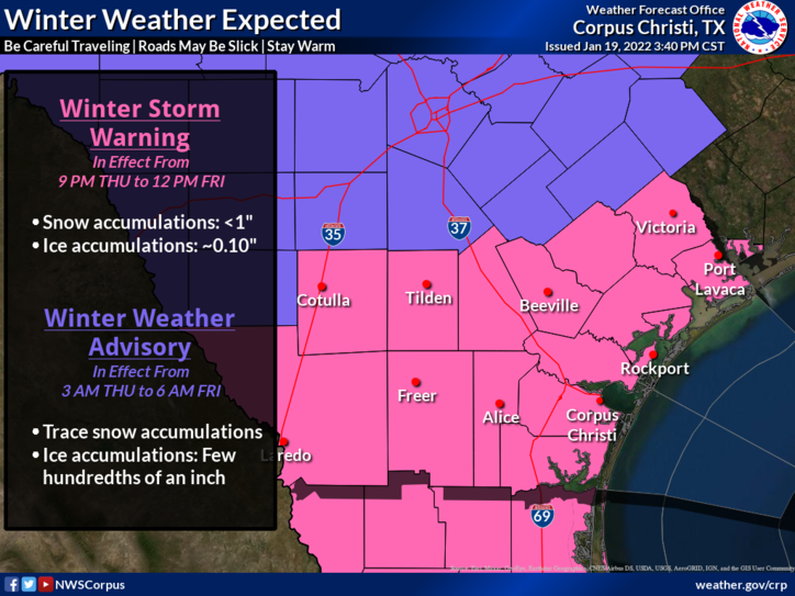
CORPUS CHRISTI (News Release) - A Winter Storm Watch is now in effect from Thursday evening through Friday morning. Freezing rain is expected during this time frame with accumulations up to 0.10". A change over to sleet and snow is also possible over the Brush Country with accumulations less than 1". Be cautious if you must travel Thursday night into Friday morning. Even minor accumulations of ice can result in hazardous conditions.
Widespread wintry precipitation and frigid temperatures will impact many regions across the country during the short-term forecast period (Wednesday evening through Friday evening). Snow, sleet, and freezing rain are forecast from New England to south Texas behind a powerful cold front moving east across the country.
https://www.weather.gov/crp/
Further South, rain and thunderstorms will continue along the cold front across the Southeast and the Gulf Coast. Some locally heavy rain of 1-2 inches is possible, but low rain rates and quick moving storms will keep the threat of flooding low. Of greater significance will be the potential for icing from the Tennessee Valley south to the Gulf Coast and southern Texas as colder air moves in behind the front Thursday evening.
While totals should remain light, with only a glaze expected for most areas, the icing may lead to slick roads, particularly bridges.
Winter Storm Watches and Winter Weather Advisories have been issued for portions of southern Texas.